5 Highway 1 Not-So-Secret Scenic Gems
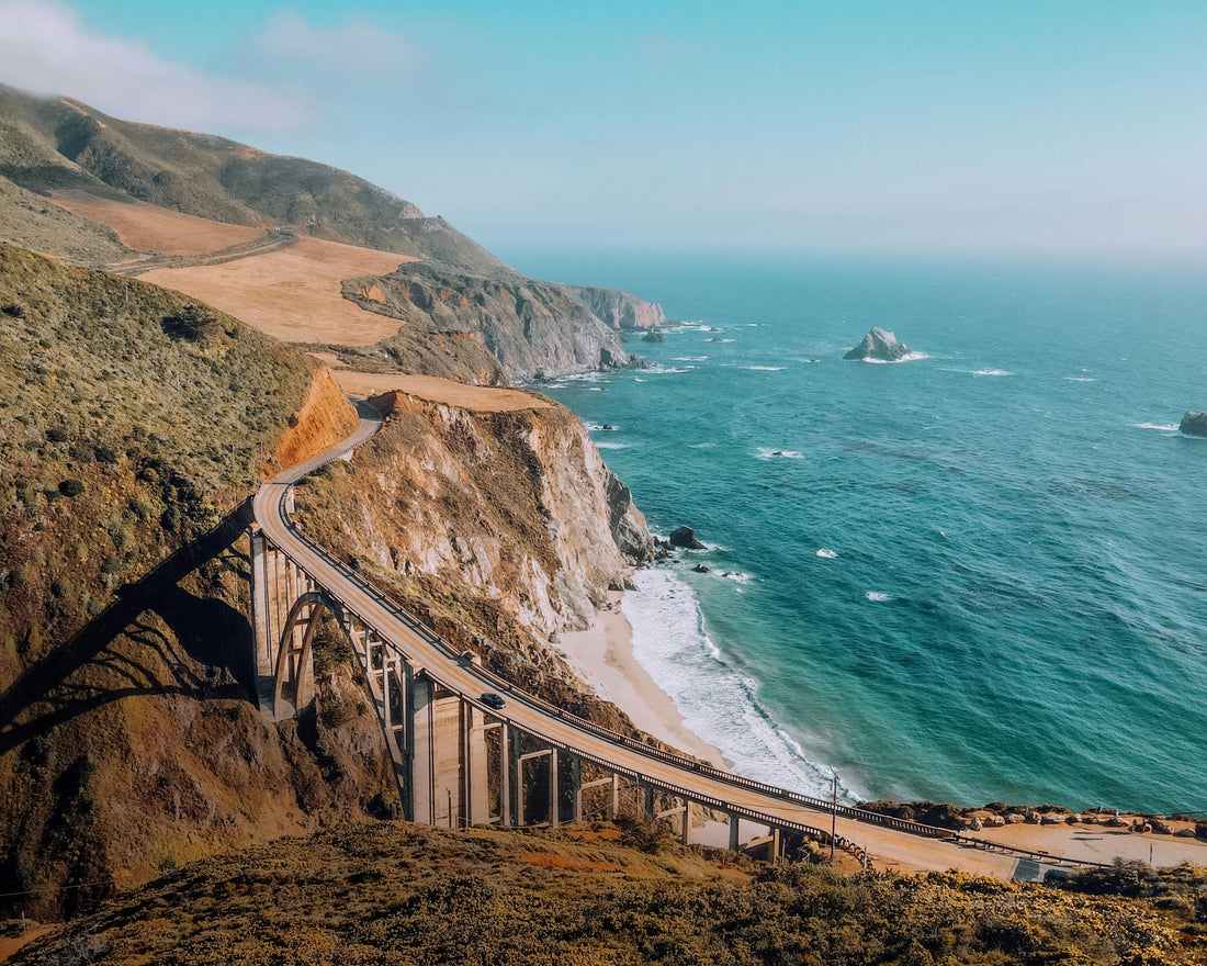
California’s iconic Highway 1 is packed with jaw-dropping ocean views and famous stops like Big Sur and Monterey. But if you know where to look, there are a few not-so-hidden-anymore gems that deserve a spot on your itinerary. These places might have gained some popularity thanks to social media—but they still carry that “wow” factor, and they’re often skipped by rushed road trippers.
From purple sand beaches to European-style villages and cliffside waterfalls, these Highway 1 stops offer scenery and experiences you won’t find anywhere else.
Let’s dive into 5 spots that are becoming everyone’s new favorite detours—for good reason.
🚏 Table of Contents
- 🌊 1. Shark Fin Cove (Davenport, CA)
- 🏡 2. Carmel-By-The-Sea Fairytale Cottages (Carmel, CA)
- 🪨 3. Keyhole Rock at Pfeiffer Beach (Big Sur, CA)
- 🌴 4. McWay Falls (Julia Pfeiffer Burns State Park)
- 🍷 5. Solvang: California’s Danish Village (Solvang, CA)
- 🎒 What to Pack for These Gems
🌊 1. Shark Fin Cove (Davenport, CA)

📍 Location: 10 minutes north of Santa Cruz, just off Highway 1
📸 Vibe: Wild, windswept, and raw
Once known mainly to locals, Shark Fin Cove (also called Davenport Cove) has become a social media darling thanks to its dramatic shark-fin-shaped rock that juts out of the water like something from Jurassic Park.
The beach itself is relatively small but incredibly scenic. Expect sea caves, tide pools, and crashing waves. The descent to the beach is short but steep, so be cautious—especially if it’s muddy.
🥾 Trail Info:
-
Shark Fin Cove Trail:
- Distance: 0.3 miles roundtrip
- Duration: ~15 minutes
- Difficulty: Easy but steep
- Trail type: Dirt path down from roadside turnout
🔍 Pro Tips:
- Park on the west side of Highway 1 near the railroad tracks (look for the dirt turnout).
- Go at low tide if you want to explore the caves.
- Sunset is stunning here, but bring a flashlight for the walk back up.
🏡 2. Carmel-By-The-Sea Fairytale Cottages (Carmel, CA)

📍 Location: Central Carmel, near Ocean Avenue
📸 Vibe: Whimsical, fairytale, Old World charm
Carmel is already one of California’s most charming coastal towns, but its storybook cottages are what make it feel like a fantasy world. Designed in the 1920s by local builder Hugh Comstock, these cottages look straight out of a European folk tale—with steeply pitched roofs, arched doorways, and ivy-covered chimneys.
Most cottages are private residences, but some can be admired from the street. Don’t miss Tuck Box, now a tea room, or Hansel Cottage, one of Comstock’s first.
🥾 Nearby Trail:
-
Carmel Scenic Pathway:
- Distance: 3.5 miles roundtrip
- Duration: ~1.5 hours
- Difficulty: Easy
- Highlights: Coastal views, beach access, benches for relaxing
🔍 Pro Tips:
- Carmel has no street numbers—bring a walking map or use GPS for landmarks.
- It’s a dog-friendly town, so feel free to bring your pup.
- Don’t miss Carmel Beach for a picnic and sunset.
3. Keyhole Rock at Pfeiffer Beach (Big Sur, CA)

📍 Location: Pfeiffer Beach, accessed via Sycamore Canyon Rd (watch for hidden entrance)
📸 Vibe: Mystical, dramatic, rugged
Pfeiffer Beach is a secluded gem tucked behind a narrow, unmarked road in Big Sur. While the beach itself is stunning with purple-tinted sand and jagged cliffs, the main attraction is Keyhole Rock—a sea arch carved by wind and water.
During winter sunsets (especially in December and January), the sun sets directly through the arch, creating a surreal light tunnel that photographers go wild for.
🥾 Trail Info:
-
Beach Access Trail:
- Distance: 0.5 miles one way
- Duration: ~20 minutes
- Difficulty: Easy
- Trail type: Sandy with some uneven terrain
🔍 Pro Tips:
- Sycamore Canyon Rd is narrow with no signs—drive carefully and arrive early, as parking fills up fast.
- There's a $12 entrance fee (cash only).
- Bring a windbreaker—the beach is notoriously gusty.
🌴 4. McWay Falls (Julia Pfeiffer Burns State Park)

📍 Location: Big Sur, about 12 miles south of Pfeiffer Beach
📸 Vibe: Peaceful, iconic, bucket-list-worthy
If you’ve ever seen a photo of a waterfall plunging onto a private beach, chances are it was McWay Falls. This 80-foot cascade is one of only two tidefalls in California, flowing directly into the Pacific Ocean (when tide is high) or onto the beach (when low).
Though you can’t go down to the beach, the overlook offers panoramic views that are unforgettable.
🥾 Trail Info:
-
McWay Falls Overlook Trail:
- Distance: 0.6 miles roundtrip
- Duration: ~30 minutes
- Difficulty: Easy
- Trail type: Paved, partially accessible
🔍 Pro Tips:
- Parking is limited inside the state park. If full, park along Highway 1 (carefully).
- Visit during golden hour for the best light and fewer crowds.
- Don’t miss the tunnel under the highway—it connects the parking lot to the trail.
🍷 5. Solvang: California’s Danish Village (Solvang, CA)

📍 Location: Santa Ynez Valley, 45 minutes from Santa Barbara
📸 Vibe: Quirky, European, charming
Solvang was founded by Danish immigrants in 1911 and still feels like a slice of Europe—complete with windmills, cobblestone streets, and half-timbered buildings. You’ll find bakeries selling aebleskiver (Danish pancake balls), wine tasting rooms, and old-school toy shops.
It’s not just a photo op—it’s a great place to stretch your legs, grab a pastry, and learn about California’s lesser-known Scandinavian history.
🚶 Local Walk:
-
Solvang Village Walk:
- Distance: 1–2 miles
- Duration: 1–2 hours
- Difficulty: Easy
- No trails—just wandering through shops and attractions
🔍 Pro Tips:
- Don’t miss Olsen’s Danish Village Bakery for pastries.
- Check out Mission Santa Inés, one of California’s original Spanish missions.
- Time your visit with Solvang’s Danish Days Festival (September) for live music and parades.
🎒 What to Pack for These Gems
Highway 1 weather can be unpredictable—foggy in the morning, sunny in the afternoon, chilly by sunset. Here’s what to keep in your daypack:
- ✅ Sturdy walking shoes or trail runners
- ✅ Light jacket or windbreaker
- ✅ Sunscreen and lip balm with SPF
- ✅ Sunglasses and a hat
- ✅ Portable phone charger or camera
- ✅ Water bottle + snacks
- ✅ Cash for parking fees and bakeries (yes, seriously)
📘 Want More Stops Like These?
These gems are just a taste of what California’s coast has to offer. Our Highway 1 RoadBook gives you a full itinerary from San Francisco to San Diego—including roadside attractions, must-eat spots, hidden hikes, and Google Maps pins so you never get lost.
🎁 Want to Save This Blog Post for the Road?
We know cell service along Highway 1 can be spotty. That’s why we created a FREE downloadable PDF version of this blog post—perfect for offline use while you're road-tripping.
✅ Save the map locations
✅ Keep trail info and packing tips handy
✅ Use it without needing Wi-Fi or data
👉 Click here to download your FREE PDF of this guide and keep these Highway 1 gems at your fingertips.